Overview
- Geographic Information
- Demographic Information
- Illinois Government
- Official Symbols

Geographic Information
|
Illinois lies in the north central part of the United States.
Much of Illinois was once covered by tallgrass prairies
that existed in the central part of the country prior to American settlement. The
northwestern part of the state is hilly and rocky, while the central part of the state is
flatter with fewer trees. The Shawnee
National Forest covers the southern part of the state.
The majority of the state's
land cover today is
croplands or grasslands. Land elevations are the highest in the northern part of the state and lowest in the
southern part of the state. A physiographic
map shows the landscape divisions in the state. There are numerous
State Parks
throughout Illinois that highlight the various geographic regions of the state. |
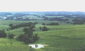
A landscape view in northwestern Illinois |
Annual rainfall in Illinois ranges from 35 inches per year in the northern part of the
state to 45 inches per year in the southern part of the state. The climate and fertile
land provide excellent growing conditions for many agricultural products, such as corn,
soybeans and wheat. Water sources in Illinois include rivers, lakes and aquifers,
which lie under the ground in the northern half of the state. The southern and central
parts of the state are rich in mineral deposits, including coal,
oil
and natural gas.
The rivers that flow through and
border Illinois have played significant roles in the development of Illinois. They were a
means of travel throughout the state for early inhabitants and explorers. Later, they provided a means for
transporting goods to markets outside of Illinois. The major rivers in
Illinois can be seen in a satellite image of the state.
The Mississippi
River flows along the entire western of the state and empties into the Gulf
of Mexico. The Wabash and Ohio Rivers flow along the eastern border of the state and join
the Mississippi River at the southern tip of Illinois.
The Des Plaines and Illinois River flow from near the Chicago area through
the central part of Illinois and join the Mississippi River near
Alton. Today, these rivers are part of the
Illinois Waterway, a system of canals and rivers through central
Illinois, which links Lake Michigan with the Mississippi River. Lake Michigan,
which borders the northeast corner of the state, allows access to the
Atlantic Ocean through the Great Lakes. |
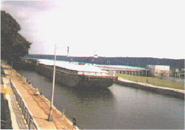
A barge makes its way along the Illinois Waterway
near Utica
|
Additional Resources
Study Guide Questions:
- What covered much of Illinois prior to American
settlement in the state?
- Identify the geographic regions of the state as shown by a
physiographic map.
- Why is Illinois such a good place for growing crops?
- Name three mineral resources can be found in abundant
supply in Illinois?
- What rivers border Illinois?
- What is the Illinois Waterway and how does it
benefit Illinois?
- What is the geographic makeup of your county? Has the geography of
your area had an impact on its economic development?
Back to Top |