| Key to Texas |
|
|
|
|
|
Texas OverviewGeographic InformationCalled the Lone Star State, Texas lies in the southwestern United States. Adjacent states include New Mexico to the west, Oklahoma to the north, Arkansas to the northeast and Louisiana in the east. On the southern border is the Republic of Mexico. Texas ranks second to Alaska among all the states in size. Texas contains about 7.5 percent of the nation�s total area and is as large as New England, Pennsylvania, Ohio and Illinois combined. Texas totals 268,601 square miles of territory and includes 4,959 square miles of inland water.
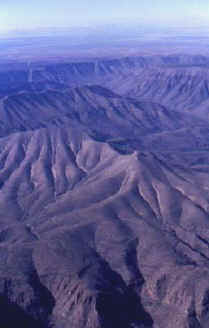
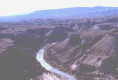
Texas has relatively few natural lakes. The biggest is Caddo Lake near the Louisiana border. It is a winding network of inlets and channels rather than a single body of open water. The state has many man-made lakes. The largest are Lake Texoma on the Red River, Toledo Bend Reservoir on the Sabine and Sam Rayburn Reservoir on a tributary of the Neches. Other lakes include Lake Texarkana, Lake Travis, Lake Lavon, Lake Ray Hubbard and Lake Livingston. Many of the lakes provide lush vacation spots for fishing, boating, swimming and for enjoying nature. Texas is rich in natural resources, including mineral deposits. It has enormous quantities of petroleum, natural gas and natural gas liquids. Those products account for 94 percent of all the mineral value in the state. Other resources are natural graphite, magnesium, sulfur, lignite (low-grade coal), salt, talc, magnesium, gypsum, molybdenum and uranium. The state also has many forests. Most are in the eastern half of the state. Varieties of trees include pine, oak, hickory, ash, magnolia, pecan, walnut and even cypress. The most valuable tree crop is the yellow pine, which is manufactured into pulp and paper. Hardwood trees, such as oak, hickory, ash and walnut, are used in making furniture or used for construction lumber. Today, emphasis is placed on conservation and scientific management of the forests, and the lumber industry is still very important in eastern Texas. The climate of the Lone Star State varies greatly. For example, most of eastern Texas has a humid, subtropical climate while the northern part of the Panhandle has a cold semiarid climate. Average rainfall varies greatly from east (as much as 55 inches annually) to west (as little as 10 inches per year). Drought is often a problem in West Texas. Hurricanes sometimes strike the Texas Gulf Coast, usually during late summer. Tornados frequently develop in Central and Northern Texas from April through May. The growing season for Texas farmers range from about 320 days along the coast to approximately 180 days in the Panhandle. Texas has a number of national parks and forests. One is the Big Bend National Park. It is located along the Rio Grande. It is noted for its epic scenery and its beautiful wild flowers. Further west is the Guadalupe Mountains National Park. The four national forests are the Sabine, Davy Crockett, Sam Houston and Angelina. All are in eastern Texas. The Lone Star State also has more than 110 state parks and five state forests. One of the largest parks is Palo Duro Canyon on the High Plains between Lubbock and Amarillo. It covers more than 15,000 acres of land.
Additional Resources
Study Guide Questions:
|
|